Most Kerala hill stations are defined by what you can see — tea gardens rolling into mist, forest canopy stretching to the horizon. Ramakkalmedu is defined by something you feel before you see anything at all. Step out of the car at the summit car park and the wind hits you like a wall — steady, cold, and completely unlike anything else in the Western Ghats. It doesn't gust and pause the way wind usually does. It simply doesn't stop.
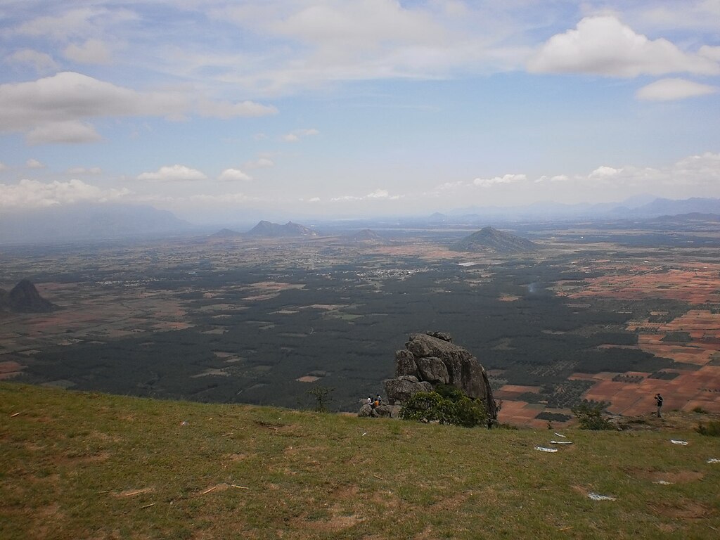
Ramakkal Medu, Idukki. Courtesy Edukeralam, CC BY-SA 4.0, via Wikimedia Commons.
That constant wind is only the beginning of what makes this Idukki hilltop unusual. Ramakkalmedu carries two very different stories at once — a classical one, tying the very name of the hill to Lord Rama's search for Sita in the Ramayana, and an indigenous one, embodied in a towering statue of a Kuravar tribal couple who are remembered for their connection to the building of the Idukki Arch Dam. Add to this a fragile Shola-grassland ecosystem, one of Kerala's earliest wind energy installations, and sweeping views across the border into Tamil Nadu, and you get a destination that resists easy categorisation. It isn't quite a wildlife park, isn't quite a plantation hill station, and isn't quite a pilgrimage site — it's all three, loosely stitched together by wind.
This guide walks through what makes Ramakkalmedu worth the detour: its geography and climate, its layered folklore, its ecology, its wind energy story, and the practical questions — how to get there, what to do, and how to visit in a way that respects both the land and the people who have lived on it for generations.
Location & Landscape
Where Is Ramakkalmedu — Standing on the Ghats' Edge
Ramakkalmedu sits in Idukki district, on a section of the Western Ghats that acts almost like a natural balcony over the plains of Tamil Nadu. It lies roughly 15 km from Nedumkandam, directly on the route that links two of Kerala's most visited highland destinations — Munnar and Thekkady — which makes it a natural stopover rather than a separate expedition. Nearby towns include Thookkupalam (about 5 km away), Kattappana (about 25 km) and Kumily near Thekkady (about 40 km), so despite its remote, wind-battered feel, it's genuinely easy to reach.
The hill stands at an elevation of roughly 1,100 metres, positioned right on the crest of the Ghats where the terrain drops away sharply toward the Tamil Nadu plains below. This edge-of-the-range position is exactly what generates the site's defining feature — but more on the wind shortly. The area falls under the jurisdiction of the Karunapuram and Nedumkandam grama panchayaths.
The rock formations here have long fed local imagination. A striking pillar-like rock face, roughly 300 metres high, rises to the east of the main viewpoint, and two other formations — locally known as Turtle Rock and Frog Rock — carry their own folk names based on their silhouettes. A short distance away at Amappara, two enormous boulders lean against each other in a formation nicknamed "Tortoise Rock," which has become a quieter, increasingly popular stop for visitors looking to explore beyond the main viewpoint.
- District Idukki, Kerala
- Elevation Approximately 1,100 metres (3,500 ft)
- Distance from Nedumkandam ~15 km
- Distance from Kumily (Thekkady) ~40 km
- On the Route Between Munnar and Thekkady
- Local Governance Karunapuram & Nedumkandam grama panchayaths
- Known Locally As Kerala's "cradle of wind"
- Key Landmarks Kuravan–Kurathi statue, wind farm viewpoint, Amappara (Tortoise Rock)
Ecology
A Fragile Beauty — Shola-Grassland Ecosystem
Behind the postcard views, Ramakkalmedu sits within one of the more ecologically delicate habitat types found in South India's high ranges: the Shola-grassland mosaic, occasionally interspersed with pockets of bamboo. This habitat type occurs in patches across the Western Ghats between roughly 1,000 and 2,200 metres elevation, and ecologists sometimes describe these high-altitude grassland patches as "sky islands" — isolated pockets of habitat separated from similar terrain by lower-elevation forest, supporting species found nowhere else nearby.
These grasslands, and the forest margins where they meet Shola forest patches, are recognised centres of endemism — meaning a disproportionate number of species found here exist only in this specific type of habitat. Similar ecosystems have been studied in more detail at Eravikulam National Park and in the Nilgiris, where researchers have highlighted how vulnerable these zones are to disturbance from invasive species, grazing pressure and development.
What this means practically for Ramakkalmedu is that its beauty and its fragility are the same thing. The open, windswept grassland that makes the summit views so dramatic is also a habitat type that recovers slowly once disturbed. This is part of why thoughtful visitors — and increasingly, researchers and conservation-minded travellers — treat Ramakkalmedu not just as a viewpoint, but as a living ecosystem worth understanding before walking through it.
Climate
The Wind That Never Rests — Kerala's Cradle of Wind
It's worth dwelling on the wind a little longer, because it genuinely is the thing that separates Ramakkalmedu from every other hill station in Kerala. Locally, and increasingly in tourism literature, the site is described as one of Asia's windiest places — and the reason isn't seasonal storm activity, but the geography itself. The Ghats crest here funnels air rising off the Tamil Nadu plains into a near-continuous stream, blowing at roughly 35 km/h through most of the year, largely irrespective of season or time of day.
What makes this remarkable isn't just the number — it's the consistency. Most windy places have windy seasons and calm ones. Ramakkalmedu's wind is closer to a constant. Stand at the viewpoint and it leans into you, tugs at loose clothing, and makes conversation at a normal volume genuinely difficult. For some visitors this is exhilarating — a natural adrenaline hit without any equipment required. For others, it becomes almost meditative: a physical force so persistent that it drowns out everything else, leaving only the present moment and the view.
"The wind here doesn't visit — it lives here. You don't experience Ramakkalmedu so much as you stand inside its weather."
— Kerala Nature Vibes · Field Notes, Idukki HighlandsThis constant wind is precisely what makes Ramakkalmedu fundamentally different from the shaded, tea-scented calm of Munnar or the dense, wildlife-focused forest cover of Thekkady. It's a sensory experience built on exposure rather than shelter — which is also, not coincidentally, exactly why this stretch of the Ghats was identified decades ago as suitable ground for wind power generation.
Folklore & Heritage
Two Stories, One Hill — Myth and Memory at Ramakkalmedu
What earns Ramakkalmedu the description "eco-folkloristic" is the way two entirely different cultural narratives sit side by side here — one drawn from classical Hindu epic, the other rooted in the lived history of an indigenous community.
The Kuravar community's history in South India is one of resilience against real hardship — traditionally hunters, gatherers, traders and craftspeople, they were unjustly labelled under the British colonial-era Criminal Tribes Act of 1871, a designation that caused lasting social stigma. Seen in that light, the statue on the hill is more than decorative public art; it's a quiet, visible act of correction — a monument that puts the Kuravar people's connection to this landscape back where it belongs, in plain sight.
Locally, this pairing of a Rama legend with a monument to indigenous history is sometimes described as making Ramakkalmedu a kind of cultural bridge — a single hilltop where a pan-Indian religious narrative and a specific, local, tribal history are both given space, rather than one crowding out the other.
Reading the Rocks — Turtle, Frog and Tortoise
Beyond the two central narratives, smaller pieces of folklore attach themselves to the landscape's odder rock formations — Turtle Rock and Frog Rock near the main viewpoint, and the leaning boulders of Amappara (Tortoise Rock) a short distance away. These local names, passed down informally rather than documented in any single source, are the kind of everyday folklore that often carries practical, half-buried knowledge — about which slopes are stable, where water tends to collect, or which areas to avoid in high wind. Traditional Ecological Knowledge like this rarely announces itself as science, but it frequently overlaps with it.
🏨 Planning to Stay Near Ramakkalmedu?
Ramakkalmedu makes an easy stop between Munnar and Thekkady, but staying a night nearby means you can catch the wind and the summit light without rushing back down. Compare homestays, hill resorts and eco-lodges in the Idukki highlands.
Affiliate links — we may earn a small commission at no extra cost to you, which helps keep this guide free.
What To Do
From Quiet Treks to Adrenaline on the Ridge
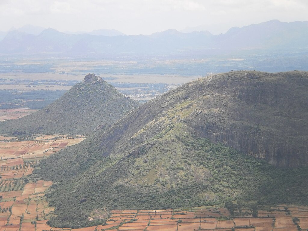
Ramakkal Medu. Courtesy Edukeralam, CC BY-SA 4.0, via Wikimedia Commons.
Ramakkalmedu works equally well for a traveller who wants a contemplative hour at a viewpoint and one chasing something more physical. Vehicles can reach a point close to the summit, but the final stretch is on foot — a short, steep walk directly into the wind, which somehow makes arriving at the top feel earned rather than simply arrived at.
Beyond the main viewpoint, the area supports hiking, casual touring, camping, and — where local operators are active — paragliding off the ridge, taking full advantage of the site's one truly unmissable resource. The Amappara rock formation a short distance away has become a popular secondary stop for visitors interested in unusual geology rather than just the panoramic view. Budget canteens and homestays around the hill support day-trippers as well as the steady stream of weekend travellers who come up from nearby towns in both Kerala and Tamil Nadu.
The View Across the Border
One of Ramakkalmedu's quieter pleasures is geographic rather than cultural: from the summit, on a clear day, you can see well into Tamil Nadu — the plains and townships of Cumbum, Theni, Uthamapalayam and the area around the Vaigai region spread out below. At dusk, as lights come on across these settlements, the view becomes a genuinely striking illustration of how close — and how different — Kerala's high ranges and Tamil Nadu's plains sit next to each other. For travellers interested in borderland geography, or simply in watching a landscape change from daylight to evening lights, this is reason enough to time a visit for late afternoon.
Sustainable Development
The Green-on-Green Question — Wind Farms in a Fragile Habitat
Ramakkalmedu's wind farms are as much a part of the landscape now as the rock formations. The site hosts one of Kerala's earlier significant wind energy installations, with turbines spread across the nearby Pushpakandam and Kuruvikanam areas. These installations — largely using NEG MICON turbines — generate over 14.25 MW of clean electricity supplied to the Kerala State Electricity Board, with additional government-run capacity contributing roughly another 10.5 MW.
For travellers and researchers interested in renewable energy, this coexistence of scenic tourism and functioning wind infrastructure is genuinely part of the site's appeal — it's rare to stand at a tourist viewpoint and watch the actual machinery of a state's clean energy transition turning in front of you.
But it isn't a simple success story, and a good guide shouldn't pretend otherwise. Wind farms placed inside fragile Shola-grassland habitat represent a real environmental trade-off — sometimes described as a "green versus green" conflict. Research on wind energy installations more broadly has documented effects on raptor and predatory bird activity, along with habitat fragmentation, noise disturbance and land-use change in the areas immediately around turbine infrastructure. Ramakkalmedu, sitting exactly at the intersection of clean energy infrastructure and a sensitive high-altitude ecosystem, is a meaningful example of why renewable energy siting decisions matter as much as the technology itself.
🔎 Why This Matters to Visitors: Understanding this tension doesn't require you to take a side — it just means seeing Ramakkalmedu clearly. The turbines aren't a flaw in an otherwise pristine landscape, and the landscape isn't simply a backdrop for the turbines. Both are real, and both deserve honest attention from anyone writing about, or visiting, this hill.
Infrastructure & Governance
Managing Growing Footfall — Infrastructure at the Summit
Ramakkalmedu's popularity has grown steadily, with visitor numbers reportedly reaching as high as 10,000 people on peak days. In response, the Kerala government has sanctioned infrastructure upgrades — reported at over ₹1.02 crore — covering new toilet facilities, canteens, fencing, handrails, seating, solar-powered lighting and improved waste management at the site.
Alongside these visitor-facing upgrades, restoration work has also been directed at cultural landmarks connected to the hill, including renovation of the Malamuzhaki Vezhambal watchtower and conservation work on the Kuravan–Kurathi sculpture itself. Together, these efforts point toward a governance approach that at least attempts to balance rising visitor demand with the practical realities of maintaining a fragile, high-footfall site.
Community-Based Tourism
A Path Forward — Putting the Kuravar Community at the Centre
If Ramakkalmedu is to grow as a destination without losing what makes it distinctive, the most credible model to look toward is close by, at Periyar Tiger Reserve. There, communities once dependent on activities like poaching, smuggling and unregulated wood-cutting were brought into conservation-linked livelihoods — eco-guiding, forest patrolling, bamboo-rafting, and conservation education — turning former threats to the forest into its most invested protectors.
Ramakkalmedu is geographically and culturally well positioned to follow a similar path, with the Kuravar community's historical and ongoing connection to this specific landscape as its natural foundation. Some local entrepreneurs are already building small-scale initiatives around rural skill development and eco-tourism, drawing on indigenous knowledge and storytelling traditions passed down through generations.
🏛️ What a Community-Based Tourism Framework Could Look Like
- Formal recognition of Kuravar cultural heritage as a foundational part of the site's tourism identity, not an add-on
- Structured training in guiding, homestay hosting, craft production and basic hospitality skills
- Community-led interpretation of local folklore (Turtle Rock, Frog Rock, Amappara) tied explicitly to ecological education about the Shola-grassland habitat
- Local involvement in ecological monitoring — tracking effects of wind farm infrastructure on bird activity and habitat health over time
- Transport and access planning that makes the site genuinely easy to reach for visitors arriving from both Kerala and neighbouring Tamil Nadu
None of this is unique to Ramakkalmedu — it's essentially the same lesson Kerala has already learned at Periyar. What makes it worth repeating here is that Ramakkalmedu has an unusually strong starting point: a community whose history is already carved, quite literally, into the hill's most visible landmark.
How Ramakkalmedu Compares
Ramakkalmedu vs. Munnar vs. Thekkady
| Destination | Primary Identity | Core Cultural Element | Distinctive Feature |
|---|---|---|---|
| Ramakkalmedu | Eco-folkloristic wind frontier | Rama legend & Kuravan–Kurathi statue | Constant ~35 km/h wind, trans-boundary views |
| Munnar | High-altitude plantation landscape | Colonial-era tea heritage | Rolling tea estates, cooler climate |
| Thekkady / Periyar | Forest & wildlife sanctuary | Forest-dweller & conservation history | Periyar Tiger Reserve, spice plantations |
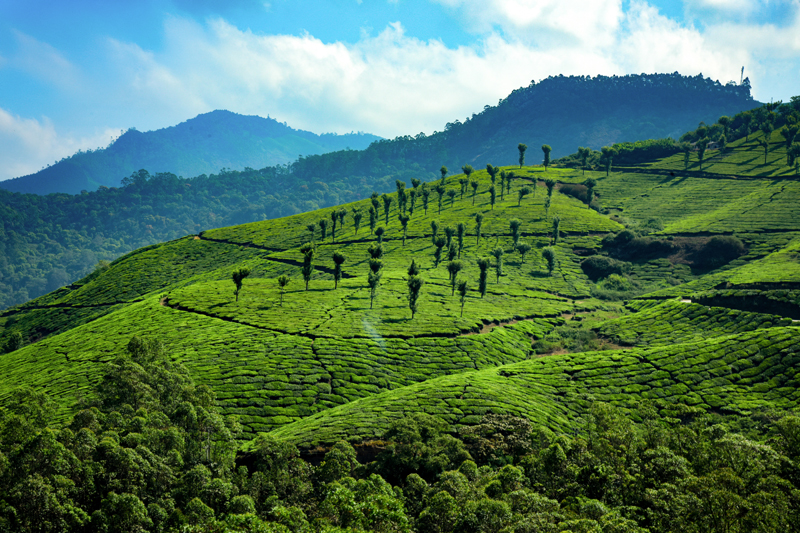
Munnar's tea estates — a gentler, shade-dominated contrast to Ramakkalmedu's open, wind-exposed ridges.
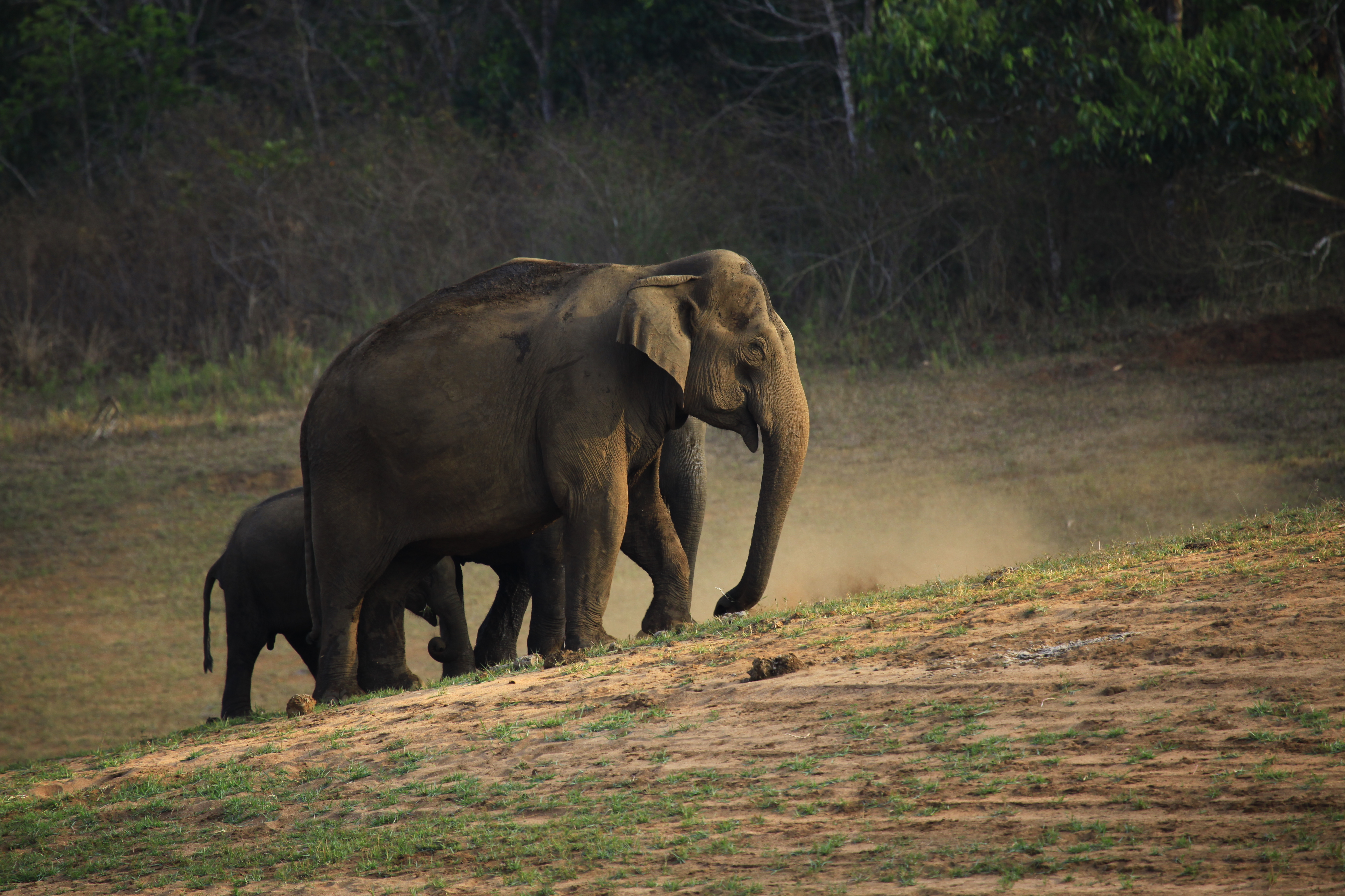
Periyar Tiger Reserve — the community-based conservation model that Ramakkalmedu could plausibly follow.
✈️ Flying Into Kochi or Thiruvananthapuram?
Ramakkalmedu is roughly midway between Kochi and Thiruvananthapuram airports, both a scenic drive up into the Ghats. Compare fares and consider flight protection, since monsoon-season delays aren't uncommon on this route.
Affiliate links — we may earn a small commission at no extra cost to you, which helps keep this guide free.
Frequently Asked Questions
Final Thoughts
Ramakkalmedu — A Hill Worth Standing Still On
Most travellers pencil in Ramakkalmedu as a short stop between Munnar and Thekkady — a photo, a walk to the statue, back in the car within the hour. There's nothing wrong with that. But the hill rewards a little more attention: the wind that makes conversation difficult is also the same physical force that shaped the ecosystem beneath your feet and, decades later, brought turbines to this exact ridge. The statue at the summit isn't incidental decoration — it's a specific, named tribute to a community whose history in these mountains predates the road that brought you here.
Whether you come for the adrenaline of standing in wind that never lets up, the quiet borderland view into Tamil Nadu at dusk, or simply a break in the drive between two more famous destinations, Ramakkalmedu asks for very little — just a willingness to notice what's actually around you. That, in the end, is what eco-folkloristic tourism really means: seeing a landscape as both a living ecosystem and a living story, at the same time.
📚 Sources & Further Reading
- Government of Kerala tourism documents and development reports on Ramakkalmedu.
- Topographical observations of the Kerala–Tamil Nadu border landscape.
- Kerala State Electricity Board (KSEB) — wind energy installation and output data.
- Local records on natural formations including Amappara (Tortoise Rock).
- Studies on ecological impacts of wind farms in Western Ghats habitats.
- Shola-grassland ecosystem research reviews, Idukki and Anamalai regions.
- Community-based conservation literature on tribal eco-monitoring in Kerala.
- Kerala Tourism — infrastructure upgrade announcements for Ramakkalmedu.
- Kerala Responsible Tourism Mission — policy briefs and reviews.
- Historical accounts of Munnar's colonial-era plantation heritage.
- Periyar Tiger Reserve — forest, wildlife and CBET management data.
- Ethnographic studies on Kuravar community heritage and folklore.
- Regional planning documents on sustainable tourism in Idukki district.